The New Series was surveyed from 1842 to 1893, and resulted in 104 sheets of 36 x 24 miles covering England and Wales (only); these were then reformatted as 360 Quarter sheets of 18 by 12 miles. In practice several of the 360 were never published or were combined (eg where two covered a lot of sea), so there were actually 340 sheets planned.
The initial Outline edition was in monochrome, from an engraved plate (mostly transferred via an electrotype; there was then a "Temporary Advanced Edition with Hills" (the latter being on a separate plate).
The sheets that covered Essex were:
| Sheet | Name | Notes | Outline Edition | Temp Adv Ed w Hills |
|---|---|---|---|---|
| 205 | Saffron Walden | Only a little of Essex, from Saffron Walden northwards |
Surveyed 1875-85; Published 1890; 1/-; (electrotyped 1890) |
Surveyed 1875-85; Published 1893; 1/- |
| 206 | Sudbury | Just a sliver of Essex south of Sudbury |
Surveyed 1875-85; Published 1890; 1/-; 2nd state electrotype in 1890, 3rd Parishes to 1888, 4th 1894 (?) |
Surveyed 1875-85; Published 1894; 1/-; Parishes to 1888 |
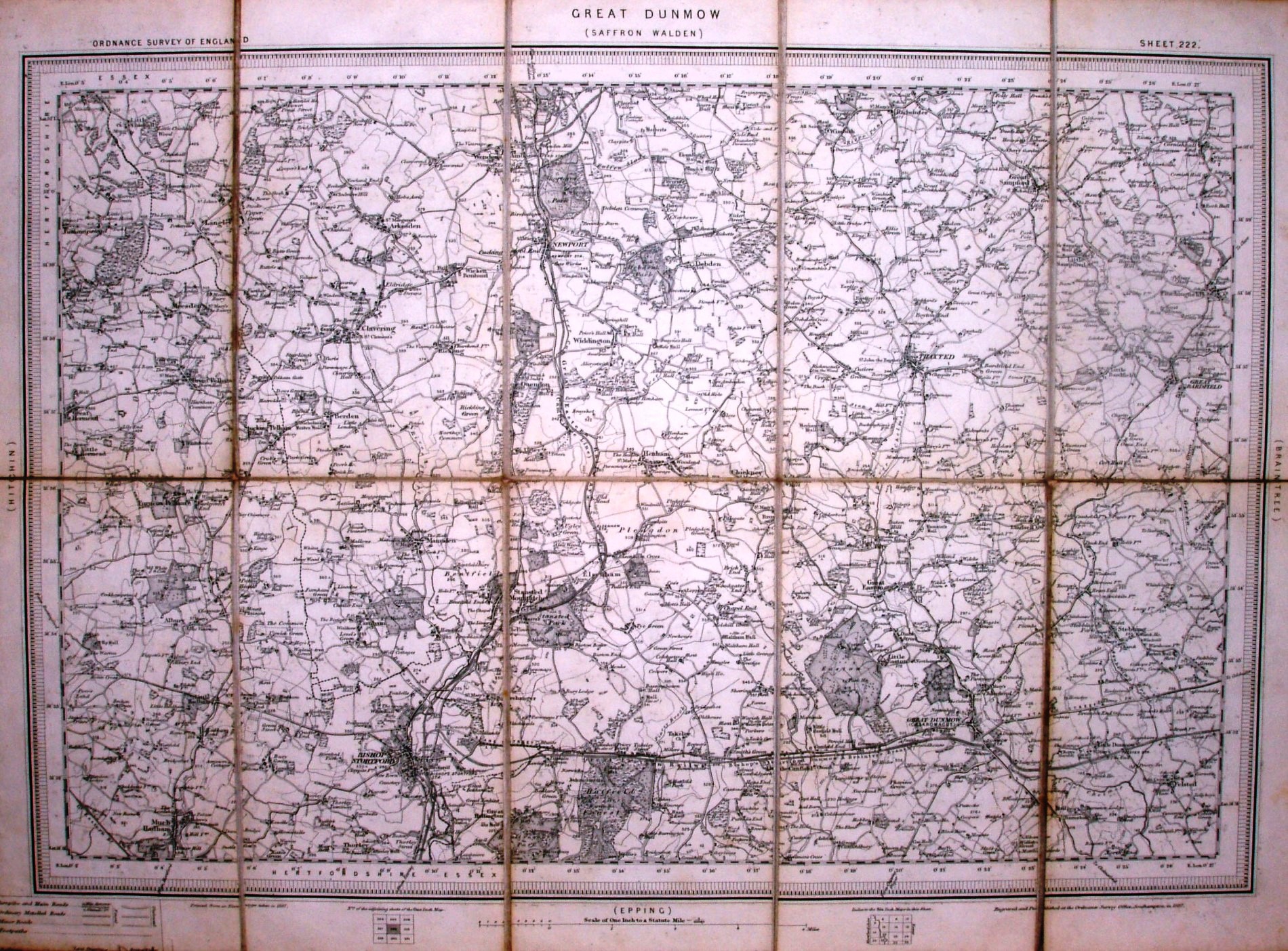
| 222 | Great Dunmow | West central Essex | Surveyed 1873-78; Published 1887; 1/-; 2nd state has Parishes to 1888 |
not published |
| 223 | Braintree | Central Essex | Surveyed 1873-85; Published 1887; 1/-; 2nd state has Parishes to 1888 |
Surveyed 1873-85; Published 1893; 1/-; 2nd state published 1895 |
| 224 | Colchester | Mostly Essex, plus Suffolk north of the Stour |
Surveyed 1861-64; Published 1889; 1/-; 6 states via electrotypes, 4th priceless or manual price stamped, 4th onwards have Parishes to 1888, 6th has long Engraved-by list |
Surveyed 1861-64; Published 1893; 1/-; 2nd state published 1895 |
| 225 | Felixstow (no final "e") |
Basically just sea, plus the tip of Harwich |
Surveyed 1879; Published 1887; 1/-; electrotype 1887, 2nd state railways to 1891 |
Surveyed 1879; Published 1893; 1/-; railways to 1891 |
| 240 | Epping | West central Essex | Surveyed 1869-78; Published 1886; 1/-; electrotype 1886, 2nd state parishes to 1889 |
Surveyed 1872-75!; Published 1893; 1/-; parishes to 1889 |
| 241 | Chelmsford | Central Essex | Surveyed 1872-75; Published 1886; 1/-; 1st state no RoW message; electrotype 1886; 2nd/3rd have RoW, and railways to 1889 |
Surveyed 1872-74; Published 1895; 1/-; railways to 1889 |
| 242 | Brightlingsea | East Essex, but a lot of sea too |
Surveyed 1872-74; Published 1884; 1/-; no RoW messages; electrotype 1884; 2nd/3rd have parishes to 1888 |
Surveyed 1873-74; Published 1894; 1/-; has RoW message; parishes to 1888 |
| 256 | North London | South west Essex, but mainly NE London |
Surveyed 1862-71; Published 1877; 1/-; 15 states; no RoW messages until 9th; 2nd, 3rd & 4th electrotype 1877; 5th electrotype 1882, railways to 1881, has parish names; 6th railways to 1883; 7th electrotype 1884, railways 1884, parishes to 1882; 8th electrotype 1887, railways 1885, parishes 1882; 9th RoW added, electrotype 1889, railways 1889, parishes to 1887; 10th electrotype 1890, railways to 1889, parishes to 1887; 11th electrotype 1891, railways to 1891, parishes to 1887; 12th electrotype 1892, railways to 1891, parishes 1887, parish names deleted; 13th railways to 1892, parishes to 1887; 14th electrotype 1892, railways to 1892, parishes 1887; 15th electrotype 18.., railways to [blank], parishes 18.. |
Surveyed 1862-71; Published 1892; 1/-; state 1 as Outline state 13; state 2 as Outline state 14 |
| 257 | Romford | Central South Essex | Surveyed 1862-73; Published 1883; 1/-; 9 states; no RoW messages until 5th; 1st, 2nd & 3rd electrotype 1883; 1st has parish names; 3rd railways to 1885; 4th electrotype 1889, railways to 1888; 5th RoW added, electrotype 1889, railways 1888; 6th electrotype 1889, railways to 1890; 7th electrotype 1891, railways to 1892, parishes to 1888, but parish names removed; 8th railways to 1892, parishes to 1888; 9th railways to 1892, parishes to 1888 |
Surveyed 1862-71; Published 1892; 1/-; as Outline state 9 |
| 258 | Shoeburyness | South east Essex, plus Thames Estuary |
Surveyed 1860-73; Published 1883; 1/-; 5 states; no RoW messages until 4th; electrotype 1883; 1st has parish names; 2nd railways to 1884, parishes to 1880; 3rd railways to 1888, parishes to 1880; 4th RoW added, railways to 1889, parishes to 1880; 5th railways to 1889, parish names removed |
Surveyed 1860-73; Published 1894; 1/-; as Outline state 5 |
| 259 | Foulness | SE tip of Essex, but mostly North Sea |
Surveyed 1872; Published 1882; 1/-; 1st state electrotype 1882, no parish names; 2nd electrotype 1882, parish names added |
not published |
| 271 | Dartford | Sliver of Essex north of the Thames |
Surveyed 1861-68; Published 1876; 1/-; 13 states published up to 1892+ |
Surveyed 1861-68; Published 1892; 1/- |
This is sheet 222, Great Dunmow, Outline Edition, published in 1887.
The sheets are all about 340mm x 500mm, with an official publication date across the bottom.
The sheets did have a legend and a scale, plus information on the survey and latest revision dates. There are in practice not many symbols in the key (eg churches do not yet have spires/towers), and railways have the same symbol for single and multiple tracks as on the Old Series. There is a small diagram showing the numbers of the surrounding sheets. Early maps did not have the Right of Way message, but they were added in around 1889.
Some New Series maps that had been published relatively early did have many revised states published, but mainly ones around London; sheets published later generally had very few revised states (see above). In fact some sheets for other parts of England were never published; the New Series maps were superseded by the Revised New Series maps.
In response to complaints from the public, the military and in Parliament, the OS had carried out a new re-survey of England and Wales, whilst the New Series map sheets were being published, and because of changes in technology and methodology the OS was able to get the far more up to date maps published before the last of the New Series sheets.
The New Series map sheets were far smaller than the Old Series ones, and when folded were a practical size for putting in pockets. The OS still did not add their own covers, however, leaving this to their agents. These were remarkably plain, but at least there was a cover, unlike for the Old Series maps (which when folded were still impractically large). The cover is about 192mm x 107mm.

One-inch engraved maps of the Ordnance Survey from 1847, Roger Hellyer and Richard Oliver, The Charles Close Society, 2009, £50. 714 + vi pages, A4 hardback. ISBN 978 1 870598 27 9
Old Series to Explorer A field guide to the Ordnance map, Chris Higley, 2011, £12, pp vi, 154, with 42 pages in colour, 179x249 mm paperback, ISBN 978-1-870598-30-9
Both available from the Charles Close Society (CCS).